Angeles Crest Highway
Joe Peterson (Webmaster)
Thursday November 27, 2025 8:19 am
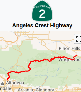
Angeles Crest Highway
Angeles Crest Highway is a 66-mile (106 km) two-lane highway over the San Gabriel Mountains, in Southern California. It runs through the San Gabriel Mountains National Monument and the Angeles National Forest. With the exception of a 1,000-foot-long (300 m) section in La Cañada Flintridge, the entire route is part of California State Route 2.
The road's western terminus is at the intersection at Foothill Boulevard in La Cañada Flintridge, and its eastern terminus at the Pearblossom Highway (State Route 138) northeast of Wrightwood. The majority of the route passes through the San Gabriel Mountains located north of the Greater Los Angeles Area. Segments of the road reach elevations above 7,000 feet (2,100 m), with a summit of 7,903 feet (2,409 m) at the Dawson Saddle, which makes this road one of the highest in Southern California.